by Cylan Blouin
About 38 million people reside within the Lake Chad Basin which is a crossing path between many bordering countries. Geographically, the entire Lake Chad watershed is within the borders of Nigeria, Niger, Algeria, Cameroon, Central African Republic, Chad, Sudan, and Libya, as seen in Figure 1. The Lake Chad Basin is one of the largest watersheds in Africa containing a large population, but one that has been shrinking within the last few decades.

Figure 1. A map is shown depicting the watershed of the Lake Chad Basin and all the countries it holds within its borders.
https://infocongo.org/en/could-cop21-save-shrinking-lake-chad/
Normally people will look for water to start a settlement because as humans we need water to drink and for agricultural purposes. Within the last 50 years, the lake has been shrinking due to rising temperatures and human overuse of the land. In total, the lake itself has shrank more than 90%, as seen in Figure 2. In 2017, approximately 20 million people were relying on the lake for its resources with an addition of 15 million by 2020. Increasing temperatures have made it difficult for crops to successfully grow. In Kanu, Nigeria, the average temperatures have above 20°C in the last ten years. The Lake’s shrinking has left many people as refugees, especially in Nigeria. Higher temperatures have led to more evaporation. Along with higher temperatures, poor management systems were put in place. According to refugees interviewed in an article by Amali Tower, from Climate Refugees.org, “lower crop yields from overgrazed land, a lack of rains and adverse climate conditions forced them to move internally within the Lake Chad region in search of more arable land.” (Tower 10).

Figure 2. A few maps in chronological order showing the shrinkage of the lake within the last few decades. https://bigthink.com/strange-maps/95-the-incredible-shrinking-lake-chad-that-is
A scattering of climate refugees and a lack of resources brought instability, which then attracted groups trying to exploit the situation. Just over a decade ago, an insurgency group, Jama’atu Ahlis Sunna Lidda’awati wal-Jihad (more commonly known as Boko Haram), launched an assault on the Nigerian government. The conflict zones are primarily in the northern parts of Nigeria in the Lake Chad Basin, and conflict has recently spilled into the neighboring countries, as shown in Figure 3. Growing tensions have led to more and more refugees. Boko Haram have even taken advantage of the current situation of the lake shrinking and taking control of the areas with water. According to the former director of the Lake Chad Commission, Abubakar Bobboi Jauro, political leaders must pacify the region first before solving the economic and climate-caused problems.
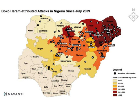
Figure 3. A map showing the conflict zones in Nigeria. https://www.vox.com/2014/5/13/5710484/boko-haram-maps-charts-nigeria
https://www.climate-refugees.org/reports/tag/Nigeria
https://indd.adobe.com/view/bf1670bb-4562-402e-a6c2-ebb3298cf8e5
https://www.vox.com/2014/5/13/5710484/boko-haram-maps-charts-nigeria
https://www.dw.com/en/lake-chad-climate-change-fosters-terrorism/a-18899499
